Active Weather with Variable Temperatures and Precipitation Continue

Today into tomorrow morning, an area of low pressure will cross northern New England after ejecting out of the Great Lakes. While this system will be predominantly plain rain showers for many in New England, the stage will be set for heavy mixed precipitation across northernmost New England, particularly northern Maine. The most widespread precipitation will fall on the north side of the low pressure system, with widespread showers across the northern tier of New England. Showers will be more scattered across central and southern New England.
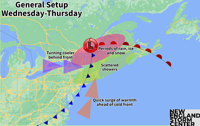
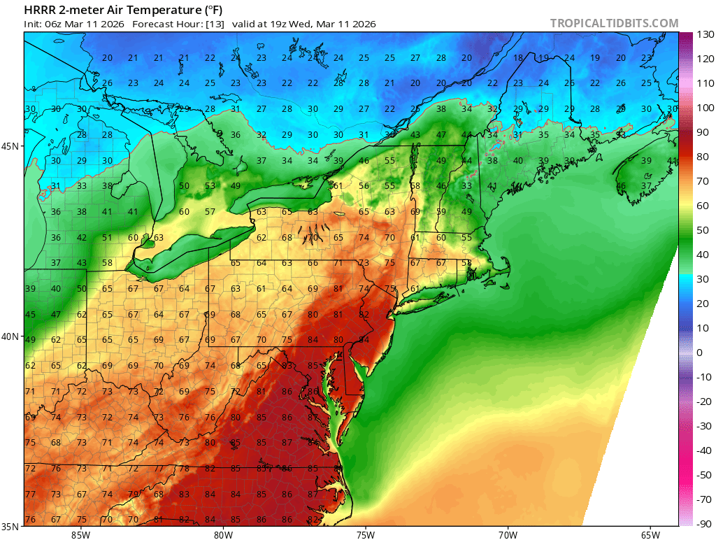
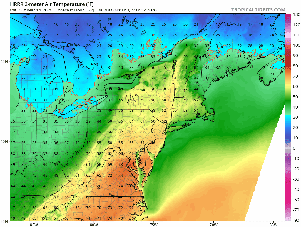
A backdoor cold front will end the widespread warmth from the past few days for most. The most mild temperatures today will be locked across westernmost New England, particularly west of the Lower Connecticut River Valley in Massachusetts and Connecticut. Here, temperatures will likely rise back into the 60s once again. The rest of southern New England may rise into the 50s while northern New England gets locked into the 30s to mid 40s.
Below: HRRR showing temperatures around mid-afternoon today:
This colder weather will help set the stage for an area of low pressure moving north of New England tonight into Thursday. This system will initially lift a warm front into New England, with mild air remaining aloft across the region. The backdoor cold front will drain colder air into the surface.
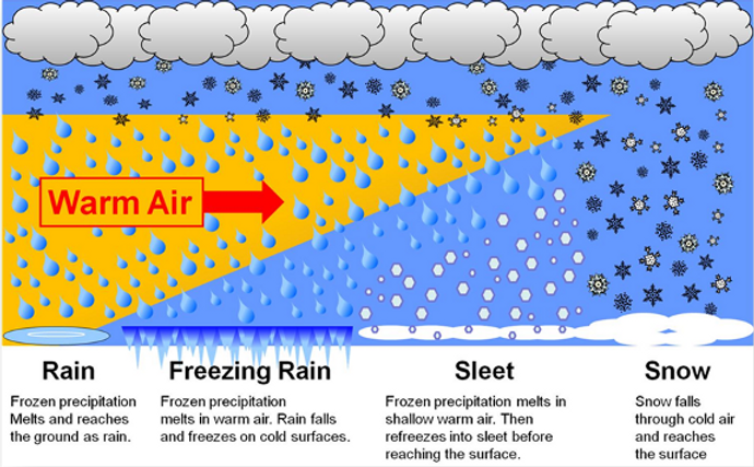
For many, this colder air will remain above freezing, resulting in plain rain showers. For northernmost New England (mainly northern Maine), temperatures will fall below freezing and remain below freezing for the duration of the storm. This is a prime setup for a wintry mix, with snow, sleet and ice.
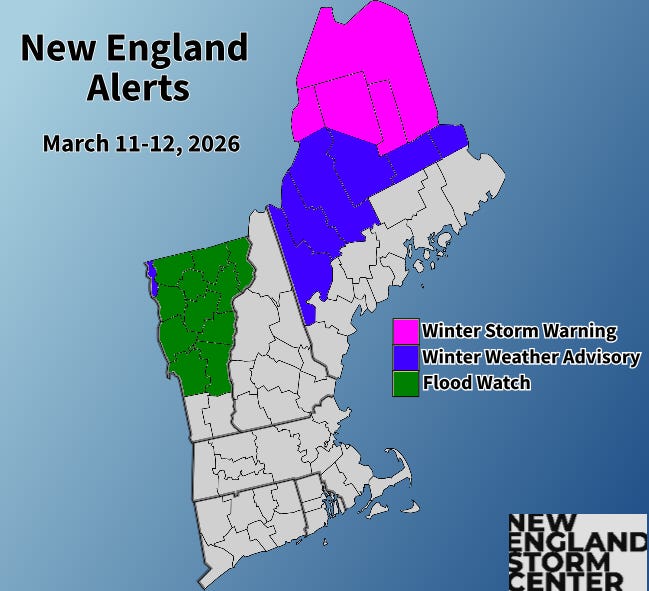
Overall, the low pressure system has trended farther north, with the storm center slated to pass near the Canadian border or across southern Canada. The main change to the forecast this northerly trend causes is a more prominent layer of mild air aloft across northern Maine. With a deeper layer of mild air, the amount of freezing rain has increased slightly while sleet and snow amounts have decreased slightly. No changes to alerts have been made since yesterday, with northern Maine under a winter storm warning.
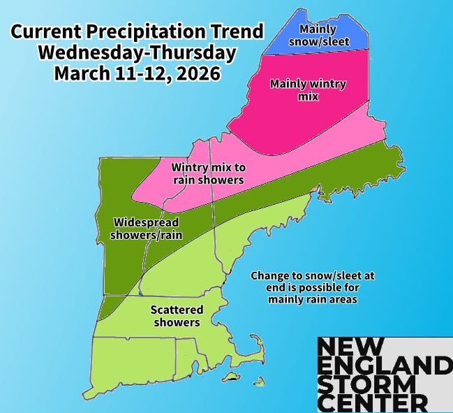
Scattered rain and freezing rain showers have broken out this morning and will continue across northernmost New England through the day today. The coverage of the wintry mix across northern Maine will fill in this afternoon as precipitation begins to become heavier. Periods of showers and steady rain will fill in across Vermont and northern New Hampshire through this evening while widespread mixing continues across Maine. Southern and central New England are likely to see periods of more scattered shower activity this evening and into the overnight.
Below: HRRR showing potential weather this afternoon (1st image) and this evening (2nd image):


With the northerly trend, the heaviest of the precipitation will impact southern Quebec rather than New England. Scattered showers will continue across New England through Thursday, but the widespread, accumulating precipitation will wrap by the morning. Moisture may be drawn northward on the back side of the cold front, allowing showers to continue once the front has passed. Should these showers hold on long enough, they may change to snow showers anywhere in New England later Thursday afternoon and evening.
Below: HRRR showing potential weather around midnight tonight (1st image) and early Thursday afternoon (2nd image):


Temperatures will also be on the decline throughout the day Thursday. The warm front will push into New England quickly, allowing for a spike in temperatures overnight tonight into Thursday morning. Highs on Thursday will be achieved in the morning for many as temperatures steadily fall throughout the day on the other side of the cold front. On paper, another day with widespread highs in the 50s and 60s will occur (outside of northern Maine), but these will likely occur early in the morning for most. Afternoon temperatures will be in the 30s and 40s for many.
Below: RGEM showing hourly temperatures from midnight Thursday morning through mid-afternoon Thursday:
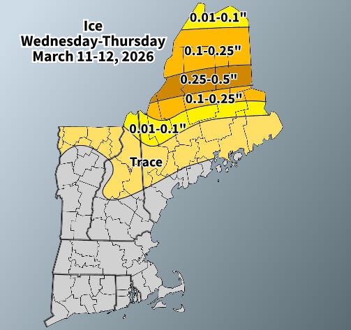
Looking at precipitation amounts, the northerly trend in the storm system has allowed for freezing rain to trend back up. A wider area of 0.1-0.25 inches of ice is likely to set up across the Maine Highlands, southern Aroostook County and into the northern Kennebec River Valley. There will be the chance for localized amounts of 0.25-0.35 inches.
At this point, the worst-case scenario for freezing rain will be up to a half inch, which is when tree damage and power outages begin to quickly ramp up. At this point, it still seems that most areas will remain around a quarter an inch with more isolated issues, but this will be something to watch carefully this evening.
The main question for icing amounts will be how quickly the milder air aloft can push in. The system will likely start out as sleet, but as the layer of milder air becomes deeper, this will likely switch to freezing rain as the evening goes on. Naturally, the slower this process occurs, the more sleet and less freezing rain will fall, which was the general thinking over the past couple days before the northerly trend in the storm’s track.
Flood watches have been posted for most of Vermont as the general half inch to inch of rain will combine with snowmelt and melting river ice to potentially cause some issues. The ice jam threat will be lower on Wednesday and Thursday than in previous days as the amount of rain and mild temperatures are expected to flush out much of the river ice, but jams will still remain possible, especially through Wednesday morning Along with the rain, an additional 1-3 inches of runoff from snowmelt is possible, with total runoff amounting to 2-4 inches across much of Vermont.
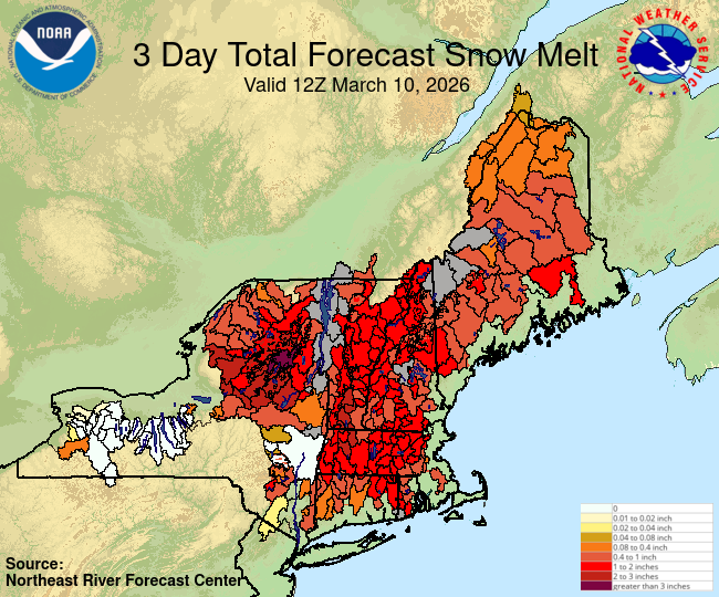
The overall flood threat seems to be low for most. Rivers that are at the highest risk of reaching minor flood stage will be the Winooski River, Mad River and Otter Creek. Currently, Otter Creek is the only one forecast to reach minor flood stage, but the others are forecast to reach action stage. With that said, ice jam flooding will remain possible anywhere with ice, though this threat is decreasing as river ice decreases.
Rivers in southern New England expected to reach action stage are the Hoosic, Housatonic, Pawcatuck, Sudbury and Taunton Rivers. The Taunton River in Bridgewater, MA is expected to reach minor flood stage and a flood warning has been issued this morning for this threat.
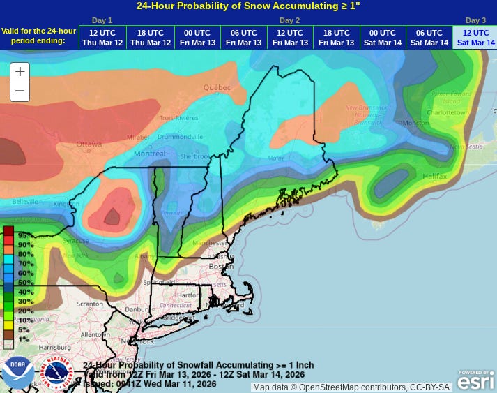
Another frontal system will likely pass through New England later Friday into Saturday morning. This will bring a quick round of snow showers to the northern tier with the potential for rain/snow or all rain showers across southern and central New England. Temperatures across the north will likely be marginal for snow, so minor accumulations are expected across the north with little to nothing expected in southern and central New England. Northern Maine will stand to see the most, with the potential for 2-5 inches, depending on the storm’s exact track.
Below: Current probability of at least 1 inch of snow from Friday morning through Saturday morning:
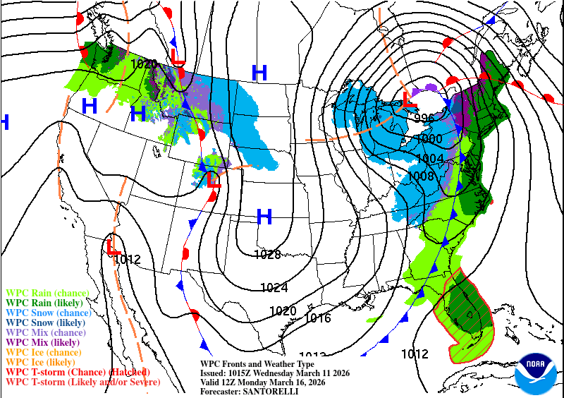
Another frontal system will quickly follow behind this one for later Sunday into Monday. This storm is very likely to be the stronger and potentially more impactful of the two upcoming with more widespread and heavier precipitation. This is looking more like a widespread rain-maker for New England as a northerly track would send a warm front into New England and allow for a strong southerly flow.
This system could be a soaking rain for much of New England with potentially strong southerly winds. It remains to be seen just how strong winds may get, and this will be determined by the strength and position of the southerly low-level jet that will cross the region. This will also determine how mild it may get during the storm. Flooding potential will need to be watched with this storm as well. The system’s strong cold front is poised to bring below average temperatures to New England around the middle of next week.
Below: Current weather map for Monday morning: